SEEING IS HALF OF IT.
KNOWING WHERE TO LOOK.
A search UAV today flies a lawnmower grid — cell 1, cell 2, cell 3, to the end of the battery. It is complete, it is predictable, and it cannot use a single thing it learns on the way. Twenty minutes of flight covers about half a 500 m square, so which half you fly is the whole problem.
Dividing by travel time means a slightly worse cell that is much closer can win. "Sweep the area around a find" is arithmetic here, not a special case.
Staleness grows in any cell nobody has looked at, so an ignored one eventually outranks a mildly interesting one. Priority changes the order, not the promise.
The Bayesian update uses our measured 0.824 recall. Because it is not 1.0, flying over a cell and seeing nobody never drives belief to zero.
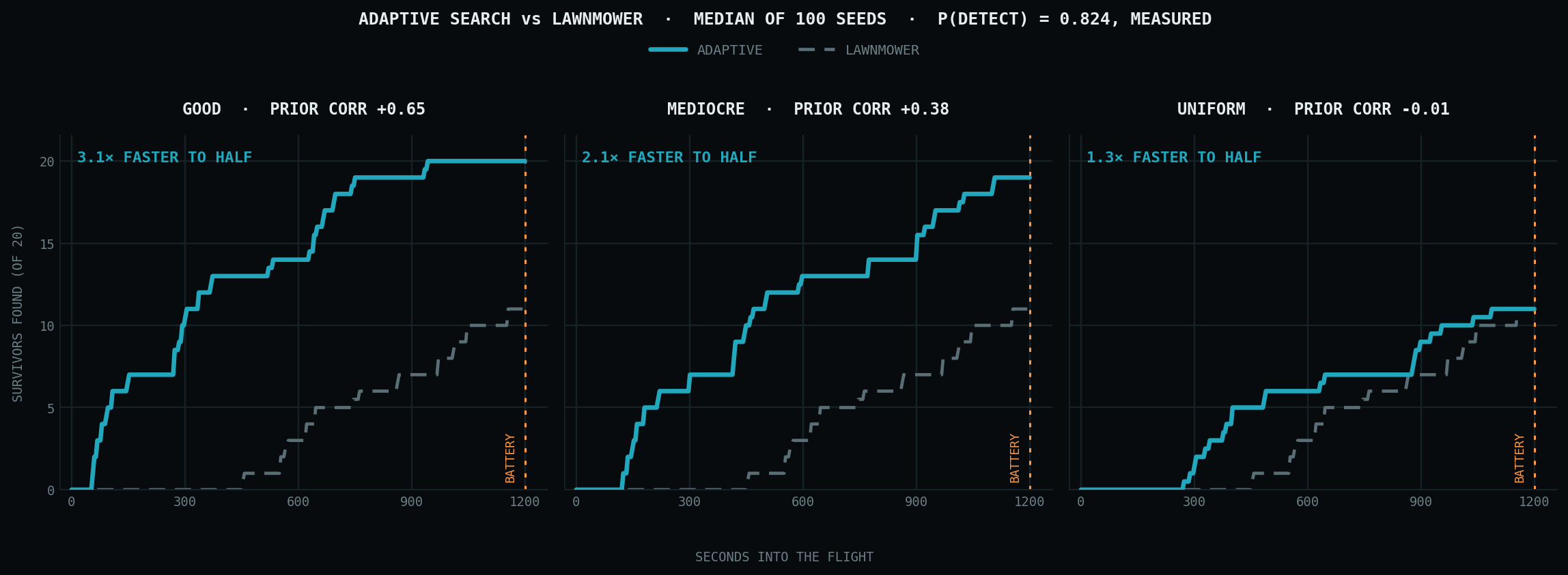
100 seeds · both planners fly identical worlds — same survivors, same battery, same detection coin-flips — so the only thing that varies is where they choose to go. Prior correlation is measured against ground truth and reported; it is not a tuned dial.
Good prior · corr +0.65
Mediocre prior · corr +0.38
Uniform prior · corr −0.01
| PLANNER | FOUND / 20 | TIME TO HALF | REACHED 80 % | AREA COVERED |
|---|---|---|---|---|
| GOOD PRIOR · CORRELATION +0.65 | ||||
| Lawnmower | 11.0 | 905 s | 10 / 100 | 55 % |
| Adaptive | 20.0 | 291 s | 81 / 100 | 33 % |
| MEDIOCRE PRIOR · CORRELATION +0.38 | ||||
| Lawnmower | 11.0 | 905 s | 10 / 100 | 55 % |
| Adaptive | 19.0 | 430 s | 79 / 100 | 42 % |
| UNIFORM PRIOR · CORRELATION −0.01 · NO INFORMATION AT ALL | ||||
| Lawnmower | 11.0 | 905 s | 10 / 100 | 55 % |
| Adaptive | 11.0 | 715 s | 18 / 100 | 48 % |
Medians across 100 seeds. The column that says the most is reached 80 %: a lawnmower gets there in 10 runs out of 100 whatever the prior, because it cannot use information. Adaptive with a usable map gets there in 81.
Rough beats nothing
Going from no information to a half-wrong map takes the count from 11 to 19 of 20. Going from half-wrong to good adds one more. So the hazard classifier's job is stop the map being blank, not be precise — and open building footprints alone would likely do most of it.
It does not collapse
At correlation −0.01 it still reaches half 1.3× faster, and 80 % in 18 runs against 10. Not from the prior — from what it learns in flight. Nothing is attractive at launch, so it starts out flying a grid; the first person it finds makes it work that ground instead of marching on. It finds no more people overall, though.
It covers less ground
33 % of the area against the lawnmower's 55 %. More people, sooner, over less ground. If the objective were map everything rather than find people fast, the lawnmower wins — and that belongs in the table, not a footnote.
“In simulation, with a detector at our measured 0.824 recall, adaptive search reached half the survivors 3.1× faster than a lawnmower grid and found 20 of 20 against 11.”
“Our system finds survivors 3× faster.”
The second is a flight claim and there is no aircraft. No wind, no GPS error, no obstacles, and survivors that do not move. The prior is synthetic — its correlation is a swept parameter, not a measurement of any real information source. Two bugs were found and fixed by watching coverage rather than the headline; both are written up in simulation/RESULTS.md along with everything above.